GEOWARN
Geospatial warning systems
Project | GEOWARN Design | Transferability | Final Product | Innovation/Outlook


Home | Links | Site Map


Authors of www.geowarn.ethz.ch:
Prof. Dr. V.J. Dietrich
Institute for Mineralogy and Petrography
ETH Zürich

Prof. Dr. Lorenz Hurni
Institute of Cartography
ETH Zürich

Project > Geological History of Sites > Volcano-Tectonic Structures in the Kos-Yali-Nisyros-Tilos Volcanic Field

Volcano-Tectonic Structures in the Kos-Yali-Nisyros-Tilos Volcanic Field

The Basal Volcanic Complex (ca. 160,000 to 100,000 years)
The Early Caldera Stratovolcano (ca. 100,000 to 30,000 years)
Lakki Pyroclastics and Avlaki Complex
Lacustrine and Pyroclastic Formations
The Melisseri - Evangelistra - Afionas Complex
The Emborios Complex
The Ellinika - Kyra - Lies Pyroclastic Complex
The Argos - Stavros Complex
The Main Caldera Formation (30,000 to 15,000 years ?)
The First Caldera Phase (?30,000 to 20,000 years ?)
The Second Caldera Phase (20,000 to <15,000 years ?)

Volcano-Tectonic Structures in the Kos-Yali-Nisyros-Tilos Volcanic Field

Three major directions of fault systems can be distinguished within the volcanic edifices of the Kos-Yali-Nisyros-Tilos volcanic field (Fig. 33).
F1) N30E faults with local changes to NE directions
F2) N30W faults with changes between N20° and N40°
F3) E-W faults
F4) N-S faults
F5) WNW-ESE (approx. 120°)

Fig. 34. Fault pattern deduced from the digital elevation model (DEM) of Nisyros Island, derived by digitizing the 1:5000 scale topographic map sheets of Nisyros Island, 1983, published by the Hellenic Military Geographical Service, Greece. Location of hydrothermal explosion craters and hot springs 
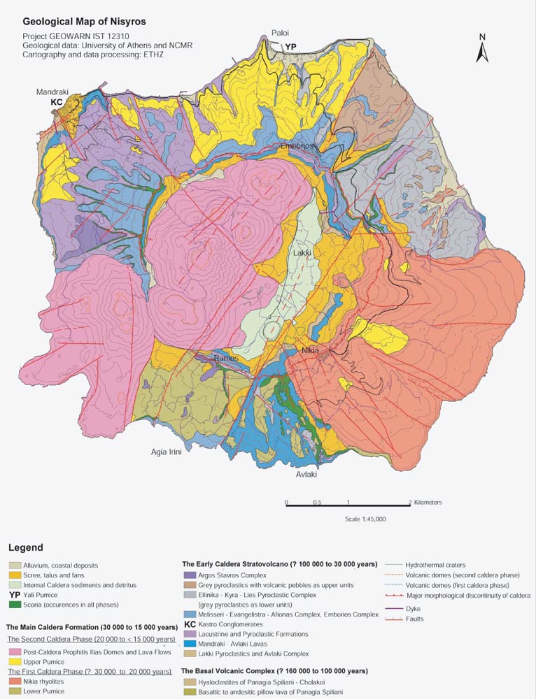
is also indicated. Swiss Federal Institute of Technology (ETHZ)
(Click on image to enlarge).
Abbreviations of localities: Av=Avlaki, Af=Afionas, CA=Cape Akrotiri, CK=Cape Katsuni, AI=Agia Irini, Le=Lefkos, Lo=Loutra, LP=Lakki plain, Ma=Mandraki, ME= Monastery Evangelistra, N=Nikia, Pa=Pali, PI= Profitis Ilias, PK=Monastery Panagia Kyra, Th=Thermiani.

Fig.35

Fig. 35 The New "Geological Map of Nisyros Volcanic Island". National Centre Marine Research (NCMR) and Swiss Federal Institute of Technology (ETHZ)
(Click on image to enlarge).


Methodologies     

Several methodologies are applied in a completely new way to achieve the necessary results.


Software screenshots

Take a look at the software graphical user interface.

Screenshot

Movies                    

Watch illustrative movies of the project.


Logo geowarn

Logo IST

Logo ETH Zürich


Back

Top 


created by geopublic

© 2003 eth zürich Legal Disclaimer
!!! Dieses Dokument stammt aus dem ETH Web-Archiv und wird nicht mehr gepflegt !!!
!!! This document is stored in the ETH Web archive and is no longer maintained !!!