GEOWARN
Geospatial warning systems
Project | GEOWARN Design | Transferability | Final Product | Innovation/Outlook


Home | Links | Site Map


Authors of www.geowarn.ethz.ch:
Prof. Dr. V.J. Dietrich
Institute for Mineralogy and Petrography
ETH Zürich

Prof. Dr. Lorenz Hurni
Institute of Cartography
ETH Zürich

Project > Geological History of Sites > 
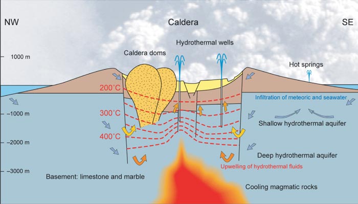
The Nisyros Hydrothermal Crater Field

The Nisyros Hydrothermal Crater Field

The Nisyros Hydrothermal Crater Field
Fumarolic Activity
The Nisyros Hydrothermal System

The Nisyros Hydrothermal System

The existence of a large hydrothermal system (Fig. 37) with brine temperatures above 500°C at 1,700 m depth is documented by the formation of five larger hydrothermal craters within the central caldera and by the occurrence of a dozen hot springs with temperatures between 30 and 60°C all located around the island at sea level. The waters of such a system are of magmatic, meteoric and seawater origin.

Fig.37

Fig. 37 Schematic cross section and geochemical model of Nisyros volcano. Swiss Federal Institute of Technology (ETHZ)
(Click on image to enlarge).

The "Geochemical model of Nisyros" (Fig. 37) is based on the chemical and the isotopic composition of the hydrothermal fluids (fumaroles and thermal springs) and the measured data of “Nis1” and “Nis2” geothermal wells.

The geochemical and deep drilling data suggest that the hydrothermal-volcanic system of Nisyros constitutes 4 main zones:

a) A magmatic body which supplies heat and fluids to the hydrothermal system. The presence of a degassing magma body is supported by the isotopic compositions of fumarolic H2O, S and He;

b) A deep boiling aquifer at temperatures of 300-350°C. The data of the geothermal wells indicate the presence of saline NaCl brines. The aquifer is fed by a mixture of volcanic and marine sources (Fig. 37);

c) Intermediate reservoirs at variable temperatures, which are fed by the vapour produced by the deeper boiling aquifer. The CO2 content of the vapour is controlled by the lowest temperatures (generally in the range 180 to 260°C) of these intermediate reservoirs. A proof for the presence of these intermediate reservoirs was established by the deep drilling of both Nis1 and Nis2, where permeable levels were found at depths from 200 to 600 m;

d) A discharge area where different kinds of manifestations are present, i.e. soil diffuse degassing structures and fumaroles (located in the Lakki plain, Fig. 36), and thermal springs (located along the coast line). A shallow hot aquifer is present in the area, fed by large quantities of condensates. The discharge area releases 68 t of hydrothermal-volcanic derived CO2 per day and 58 MW of thermal energy through diffuse soil degassing.


Methodologies     

Several methodologies are applied in a completely new way to achieve the necessary results.


Software screenshots

Take a look at the software graphical user interface.

Screenshot

Movies                    

Watch illustrative movies of the project.


Logo geowarn

Logo IST

Logo ETH Zürich


Back

Top 


created by geopublic

© 2003 eth zürich Legal Disclaimer
!!! Dieses Dokument stammt aus dem ETH Web-Archiv und wird nicht mehr gepflegt !!!
!!! This document is stored in the ETH Web archive and is no longer maintained !!!