|
|
| |
|
Project > Methodologies > Thermal Infrared (IR) Camera Imaging for Ground-Based Remote Thermal Monitoring
Thermal Infrared (IR) Camera Imaging for Ground-Based Remote Thermal Monitoring
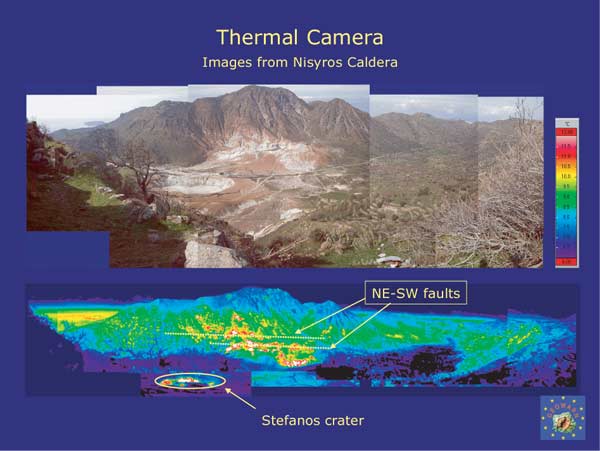
Thermal Infrared (IR) Camera Imaging for Ground-Based Remote Thermal Monitoring IntroductionA thermal tracer camera (Thermo Tracer NEC TH7100) has been used in precise thermal investigations in the Nisyros caldera which monitor fumarolic and hot spring temperatures, as well as in the Solfatara fumarolic field and in the Vesuvius summit crater. Three main advantages exist for the use of such an infrared imaging system
for volcanic monitoring: Fig. 31 Infrared thermal images recorded with portable NEC
thermal tracer. Upper picture: Daylight digital image; lower picture: infrared
thermal image of the Nisyros hydrothermal crater field, acquired before sunrise.
Temperature variation 18 to 32°C. Swiss Federal Institute of Technology
(ETHZ)
|
|
||||||||||||||||||||||||||||||||||||||||||||||||||||||
|
© 2003 eth zürich | Legal Disclaimer |
|
!!! Dieses Dokument stammt aus dem ETH Web-Archiv und wird nicht mehr gepflegt !!!
!!! This document is stored in the ETH Web archive and is no longer maintained !!! |
||