
|
|
| |

|
Home
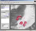
Geowarn - Geospatial Warning Systems - Nisyros Volcano, GreeceQuiescent but active volcanoes in regions of high geodynamic unrest represent a severe hazard and risk potential and require integrated monitoring, satellite surveying and data modeling. Geodetic, seismic and geochemical monitoring data together with satellite images are transformed and unified in a coherent way to allow integration into a geographic information system (GIS). A completely new, interactive, and user-friendly software tool has been developed as a web-based multimedia platform encompassing a workflow of graphical 2 to 4D landscape models and all monitored data.
|
|
||||||||||||||||||||||||||||||||||||||||||||||||||||||
|
© 2003 eth zürich | Legal Disclaimer |
|
!!! Dieses Dokument stammt aus dem ETH Web-Archiv und wird nicht mehr gepflegt !!!
!!! This document is stored in the ETH Web archive and is no longer maintained !!! |
||