GEOWARN
Geospatial warning systems
Project | GEOWARN Design | Transferability | Final Product | Innovation/Outlook


Home | Links | Site Map


Authors of www.geowarn.ethz.ch:
Prof. Dr. V.J. Dietrich
Institute for Mineralogy and Petrography
ETH Zürich

Prof. Dr. Lorenz Hurni
Institute of Cartography
ETH Zürich

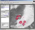
Transferability of GEOWARN systems to other European volcanoes > The second test site Campi Flegrei (Italy) - a transferability test

The Second Test Site Campi Flegrei (Italy) - a Transferability Test

The entire acquired data set for Campi Flegrei - Solfatara, was captured, corrected, georeferenced and unified within the GEOWARN database. The dataset has a similar structure to the Nisyros (Greece) site.

Spatial data and information has been processed, including aerial photographs and satellite imagery (orthorectified). Microseismic events can be analyzed in 3-D mode. The geological map of Campi Flegrei, containing all tectonic and volcanic features, was prepared as one of the cartographic backgrounds.

Several processed CO2 flux grids are incorporated and can be analyzed using the grid analyzer tool of the GEOWARN software.

Fig.43

Fig. 43 The geological map of Campi Flegrei, containing all tectonic and volcanic features, overlaid over a shaded topographic relief (ETHZ)
(Click on image to enlarge).


Methodologies     

Several methodologies are applied in a completely new way to achieve the necessary results.


Software screenshots

Take a look at the software graphical user interface.

Screenshot

Movies                    

Watch illustrative movies of the project.


Logo geowarn

Logo IST

Logo ETH Zürich


Back

Top 


created by geopublic

© 2003 eth zürich Legal Disclaimer
!!! Dieses Dokument stammt aus dem ETH Web-Archiv und wird nicht mehr gepflegt !!!
!!! This document is stored in the ETH Web archive and is no longer maintained !!!