
|
|
| |

|
Project > Methodologies > Oceanographic and Geophysical Surveys
The Ocean Floor Mapping System Using Sea BeamDetailed investigations of the regional bathymetry (Fig. 5) and of the sub-seafloor structures serve as the basis for the understanding of the neotectonics and of the Quaternary to historical volcanic activity. They include the spatial distribution of all eruption centres, the sea floor topography, and all structural and tectonic features. 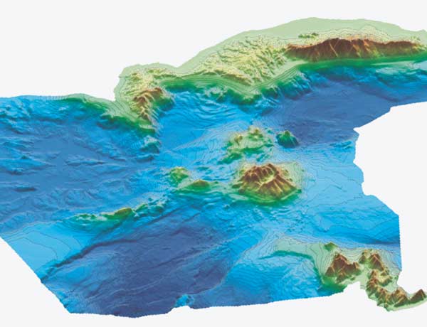
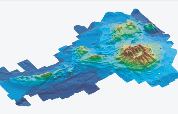
Fig. 5 Three-dimensional perspective diagram of the new
bathymetry and morphology of the Kos-Yali-Nisyros-Tilos volcanic field with
Nisyros volcanic island featured in the centre, viewed from south. 50 m contour
lines are indicated. Data derived from a combination of surveys by SeaBeam 1180
and 2120. National Centre for Marine Research NCMR, Hellenikon) The "ocean floor mapping system" (Figs. 5, 6, and 7) consists principally
of two essential units: the deep-water unit and the shallow water unit. Four
main auxiliary sensors on board and the relevant peripherals for data storage,
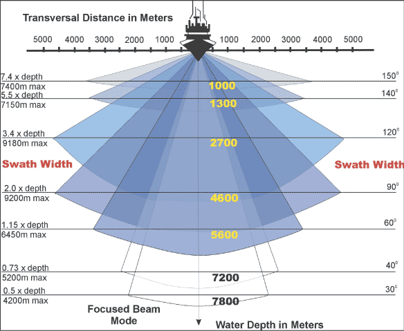
post-processing and presentation accompany these units. Deep water unit - SeaBeam 2120SeaBeam 2120 is a new swath system that has been specifically designed to accommodate users with survey requirements exceeding 6,000 m water depth, accomplishing a satisfactory resolution (up to 10 x 10 m ) without mounting a very large array (Fig. 5). The first installation of this type with a 1.80 beam width was completed during 2000 on board the AEGAEO. Fig. 6 Performance of the SeaBeam 1180 system Shallow water unit - SeaBeam 1180SeaBeam 1180 (180 kHz) is a portable, compact shallow water multibeam bathymetric
survey sonar system integrating transmitter, receiver, interfaces and power
stage within a single unit. Fig. 7 Three-dimensional perspective diagram of the new
bathymetry and morphology of Nisyros volcanic island and neighbouring islets,
viewed from the south. 50 m contour lines indicated
|
|
||||||||||||||||||||||||||||||||||||||||||||||||||||||
|
© 2003 eth zürich | Legal Disclaimer |
|
!!! Dieses Dokument stammt aus dem ETH Web-Archiv und wird nicht mehr gepflegt !!!
!!! This document is stored in the ETH Web archive and is no longer maintained !!! |
||